Creating & Editing Map Definitions
Purpose/Overview
In this article, you will learn how to create and edit map definitions for facility locations and responsibility areas in Utilisphere. You can define geographic boundaries by importing compatible shapefiles or by creating and modifying shapes with the built-in drawing tools.
Map definitions help your organization display facility locations and establish responsibility areas for ticket screening, assignment, and other map-based workflows. Because an existing map definition cannot be edited directly, you must create a new version or copy an existing version before changing its geographic boundaries.
Navigation Path:
To access this feature, go to: Utilisphere > System Management > Administration > General > Map Definitions
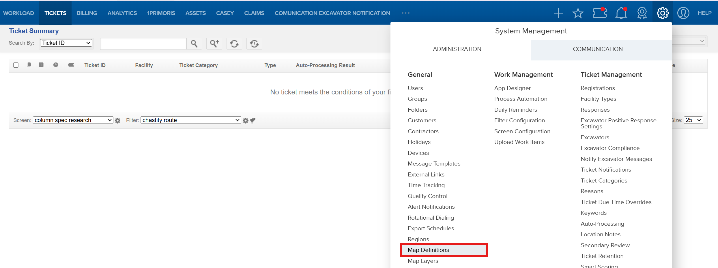
TABLE OF CONTENTS
Things to Know:
- A map definition must be active before it can be copied.
- Existing map definitions cannot be edited directly. To make changes, create a new definition or copy an existing active definition.
- Although the most recent version is typically the preferred version to copy, review the selected version to confirm that its geographic boundaries are accurate.
- You can add geographic boundaries to a map definition. However, individual shapes or imported files cannot be removed after they have been added.
- If your organization does not have a GIS department or another way to create compatible shapefiles, use the drawing tools to define geographic boundaries.
- Shapes created with the drawing tools must be merged before they can be saved.
- Only one version of a map definition can be active at a time. Activating a new version deactivates the previously active version, but the previous version remains available and can be reactivated.
- Shapefiles must meet the format, geometry, coordinate-system, component-file, and size requirements described in this article.
Shapefile Requirements
Before importing a shapefile, confirm that it meets the following requirements:
- The file must use the ESRI shapefile format.
- The geometry must be buffered or a polygon.
- Lines, polylines, and centerlines are not compatible with the shapefile import process.
- Buffers or features must be at least 10 feet. Features smaller than 10 feet may fail to process.
- The coordinate system must be NAD83 with a latitude/longitude projection, EPSG:4269.
- State Plane projections are not supported and must be converted to the required coordinate system before importing.
- The shapefile must be smaller than 200 MB.
- All three of the following component files are required:
.shp.dbf.shx
The .shp, .dbf, and .shx files must belong to the same shapefile.
| Important: Verify the shapefile’s coordinate system before beginning the import. State Plane files must be converted to NAD83 with a latitude/longitude projection, EPSG:4269, before importing them into Utilisphere. |
Key Benefits/Use Cases:
- Display facility locations: Show underground facilities or other protected geographic locations on Utilisphere maps.
- Support ticket screening: Use buffered facility locations to determine whether a mapped dig site intersects a protected area.
- Assign tickets by geography: Use responsibility areas to assign tickets to the appropriate locator, group, or office.
- Support auto-processing: Use facility locations and responsibility areas as part of configured ticket-processing workflows.
- Create boundaries without GIS files: Use the drawing tools when compatible shapefiles are not available.
- Maintain map-definition versions: Create, release, and activate updated definitions without removing previously released versions.
Facility locations can visually represent protected locations and support ticket screening. Responsibility areas define geographic areas used to place or assign tickets
How It Works:
Create a Facility Location or Responsibility Area
Go to System Management > Administration > General > Map Definitions.
Select Facility Location/Responsibility Area Summary.

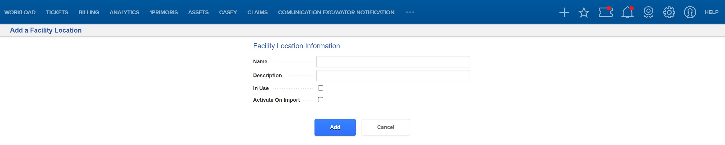
Select Add a Facility Location/Add a Responsibility Area to create a facility location or responsibility area.


Complete the applicable fields:
- Name: Enter the name of the facility location or responsibility area.
- Description: Enter relevant notes or an explanation of the location or area.
- In Use: Select this option if the facility location or responsibility area is used by your organization.
- Activate on Import: Select this option if the imported definition should become active immediately after the import is completed.
For responsibility areas, select one or both of the following applications:
- Ticket Management: Displays the responsibility area on ticket maps.
- Work Item Management: Displays the responsibility area on work-item maps.
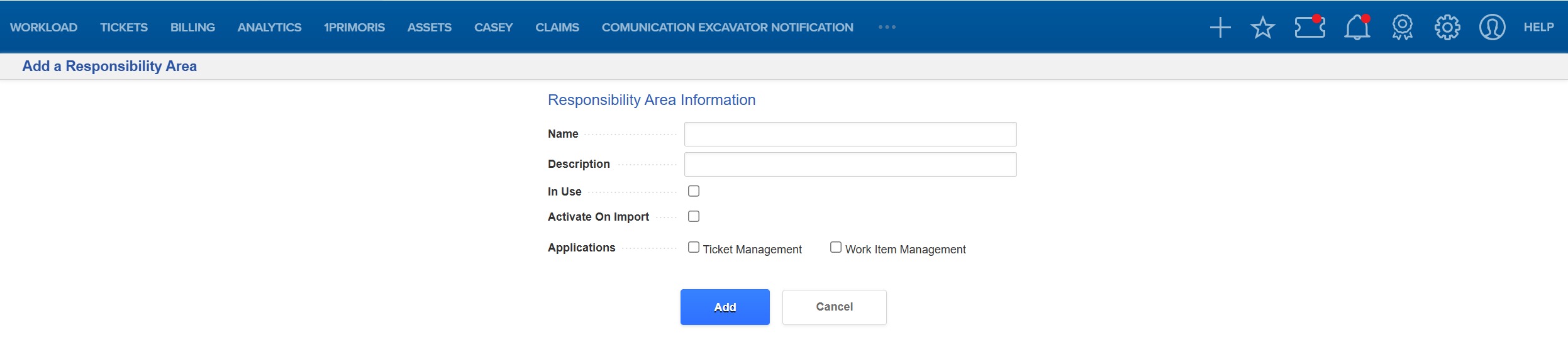
- Select Add.
Definition Fields
| Field | Description |
| Name | The name used to identify the responsibility area or facility location. |
| Description | Notes or explanatory information about the responsibility area or facility location. |
| In Use | When selected, the facility location or responsibility area is being used by your organization. It appears on the map using the color configured for definitions that are in use. When this option is not selected, the location or area remains visible on the map but is identified as not in use. |
| Activate on Import | When selected, the imported GIS definition becomes active after the import is completed. |
| Active Registration Version | Displays the version number of the active map definition. If no map definition is active, the field displays Unspecified. This field appears after a map definition has been created. |
| Applications | For responsibility areas, identifies whether the area appears in Ticket Management, Work Item Management, or both. |
Define the Geographic Area
After creating a facility location or responsibility area, define its geographic boundaries by importing a shapefile or using the Utilisphere drawing tools.
From Facility Location/Responsibility Area Summary, select the map definition you want to update.

Select the linked version number to open the Location/Area Definition page.
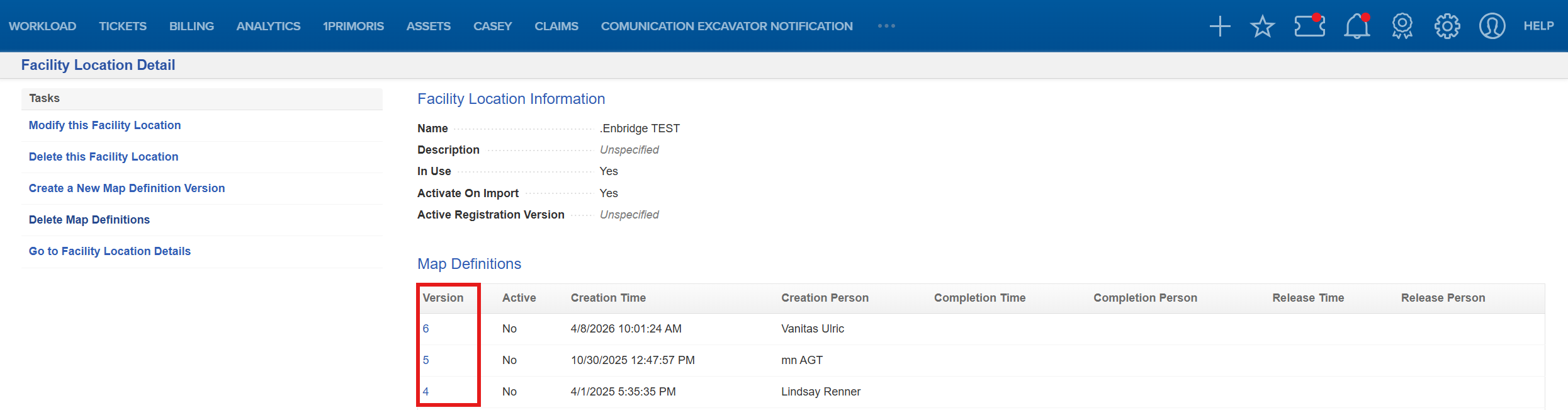
Create a new definition or copy an existing definition.
To copy an existing definition, select Add a map definition based on this definition.
Review the selected version before continuing. Although the most recent version is typically preferred, confirm that the version’s geographic boundaries are accurate.
Choose one of the following methods:
- Import a shapefile.
- Use the drawing tools.
Import a Shapefile
Before beginning the import, confirm that:
- The shapefile contains buffered or polygon geometry.
- The buffers or features are at least 10 feet.
- The shapefile is smaller than 200 MB.
- The shapefile uses NAD83 with a latitude/longitude projection, EPSG:4269.
- The
.shp,.dbf, and.shxfiles are available. - All three component files belong to the same shapefile.
A line, polyline, or centerline must be buffered or converted to polygon geometry before it can be imported for auto-processing.
Verify the Coordinate System
Review the shapefile’s coordinate system before uploading it. The required coordinate-system settings are:
- Datum: NAD83
- Projection: Latitude/longitude
- EPSG code: 4269
State Plane projections are not compatible with the import process. Convert the shapefile to NAD83 latitude/longitude, EPSG:4269, before importing it into Utilisphere.
Upload the Shapefile
From the Location/Area Definition page, select Import from shape file.

For each of the three required file types, select Choose File.

Locate and select the corresponding files:
.shp.dbf.shx
Confirm that all three files belong to the same shapefile.
Select Upload.
Repeat the import process as needed to add other compatible GIS files to the definition.
The selected files are sent to the Utilisphere map server for processing.
Verify the Imported Definition
After the import is processed, review the map and confirm that:
- The imported shape appears in the expected geographic location.
- The shape has the expected scale and dimensions.
- Facility buffers align with the appropriate protected facilities.
- Responsibility areas cover the intended assignment territory.
- No required geographic areas are missing.
A shape that appears in the wrong location or at an unexpected scale may use an unsupported or incorrectly defined coordinate system.
If the imported shapefile fully defines the facility location or responsibility area, no additional geographic changes are required. If additional boundaries are needed, import another compatible shapefile or use the drawing tools.
Use the Drawing Tools
If a compatible shapefile is unavailable, use the drawing tools to create or edit the geographic boundary.
From the Location/Area Definition page, select Edit above the upper-right corner of the map.
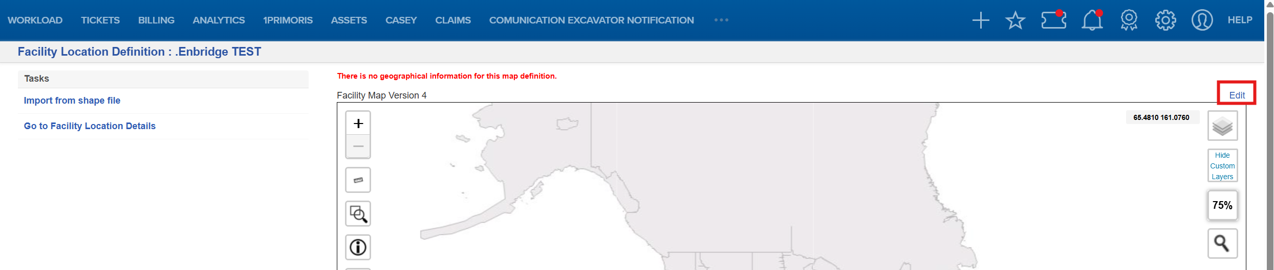
Confirm that the drawing tools appear on the right side of the map.
Select the appropriate drawing tool.
Draw the facility location or responsibility area on the map.
Configure the point or line buffer when applicable.
Select Merge to combine the shapes and apply them to the map layer.
Confirm that the merged shapes change color.
Select Save.
Select Complete.
Select Release.
If the version should become the active definition, select Activate.
Drawing Tools
| Tool | Description |
 Circle Circle | Draws a circle on the map. |
 Delete Layer Delete Layer | Deletes the selected layer and all shapes on that layer.
|
 Edit Layer Edit Layer | Allows you to modify shapes on a drawing layer. |
 Marker Marker | Adds a point to a layer. Configure the buffer applied to the point under Settings > Point Buffer. |
 Merge Merge | Combines the shapes and applies them to the map layer. Shapes must be merged before they can be saved. After they are merged, the shapes change color. |
 Polygon Polygon | Draws a multi-sided shape. |
 Polyline Polyline | Draws connected straight lines. |
 Rectangle Rectangle | Draws a rectangular shape. |
 Scissors Scissors | Cuts a selected area from a drawn shape. |
 Settings Settings | Allows you to configure point and line buffers. The default buffer is 250 feet. Point Buffer Line Buffer |
Cut an Area from a Drawn Shape
Select the appropriate drawing tool.
Draw a shape over the portion of the original area you want to remove.
Select Scissors to cut the selected area from the original shape.
Review the updated shape.
Select Merge to combine and apply the updated shapes.
Confirm that the merged shapes change color.
Save, Release, and Activate the Definition
After completing the geographic boundaries:
Select Save to save the map changes.
Select Complete to mark the definition as complete.
Select Release to release the definition.
Select Activate if the version should become the active map definition.
After the version is activated:
- The new version becomes the active map definition.
- The previously active version becomes inactive but remains listed.
- The previous version can be reactivated later.
- The active version number appears above the map on the Facility Location/Responsibility Area Definition page.
- The active version number also appears in the Active Registration Version field on the Details page.
FAQ/Troubleshooting:
Q: Why did my State Plane shapefile fail to import?
A: State Plane projections are not supported. Convert the shapefile to NAD83 latitude/longitude, EPSG:4269, before importing it into Utilisphere.
Q: Why does my imported shape appear in the wrong location?
A: The shapefile may use an unsupported projection or may have an incorrectly defined coordinate system. Confirm that the file uses NAD83 latitude/longitude, EPSG:4269, before importing it again.
Q: Why did my line, polyline, or centerline fail to import?
A: Lines, polylines, and centerlines are not compatible with the shapefile import process. Apply an appropriate buffer or convert the feature to polygon geometry before importing it.
Q: Is there a minimum buffer or feature size?
A: Buffers and features must be at least 10 feet. A feature smaller than 10 feet may fail to process.
Q: Which shapefile component files are required?
A: The .shp, .dbf, and .shx files are required. All three component files must represent the same shapefile.
Q: What is the maximum shapefile size?
A: The shapefile must be smaller than 200 MB.
Q: Where can I review shapefile import errors?
A: Go to Settings > Communications > Alerts to review available error messages.
Q: Why can’t I edit an existing map definition directly?
A: Map definitions use versions. Create a new definition or copy an existing active definition, and then make the necessary changes to the new version.
Q: Why can’t I copy a map definition?
A: The map definition must be active before it can be copied.
Q: Can I remove a shapefile or individual shape after adding it?
A: You can add boundaries to a map definition, but imported files and individual shapes cannot be removed after they have been added. If necessary, create a new version based on an accurate previous definition.
Q: Why weren’t my drawn shapes saved?
A: Confirm that you selected Merge before selecting Save. Drawn shapes must be merged before they can be saved.
Q: What happens to the previously active map definition when I activate a new version?
A: The previous version becomes inactive but remains listed and can be reactivated later.
Q: What should I do if I cannot create a compatible shapefile?
A: Use the Utilisphere drawing tools to define the facility location or responsibility area directly on the map.
Questions? Contact us!

Was this article helpful?
That’s Great!
Thank you for your feedback
Sorry! We couldn't be helpful
Thank you for your feedback
Feedback sent
We appreciate your effort and will try to fix the article